


Issued at 2:30 am AEST Friday 22 March 2019. (Bom)

Issued at 2:30 am AEST Friday 22 March 2019.
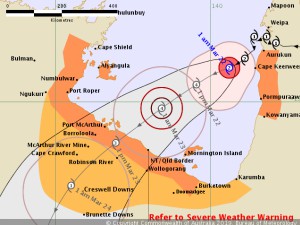
Tropical Cyclone Trevor will continue to intensify in the Gulf of Carpentaria. A severe impact on the southwestern Gulf of Carpentaria coast is likely over the weekend.
Details of Tropical Cyclone Trevor at 1:00 am AEST:
Intensity: category 2, sustained winds near the centre of 110 kilometres per hour with wind gusts to 155 kilometres per hour.
Location: within 20 kilometres of 13.9 degrees South, 140.6 degrees East , 135 kilometres west southwest of Aurukun and 455 kilometres east of Alyangula .
Movement: southwest at 10 kilometres per hour .
Tropical Cyclone Trevor is located over water in the eastern Gulf of Carpentaria.
Tropical Cyclone Trevor will intensify further as it adopts a more general southwest movement across the Gulf of Carpentaria tonight and during Friday. It is likely to cross the Northern Territory coast during Saturday as a category 4 severe tropical cyclone.
GALES, with gusts in excess of 90 km/h, are likely across western parts of Cape York Peninsula between Aurukun and Kowanyama through tonight and possibly continuing into early Friday morning.
GALES, with gusts in excess of 90 km/h, are also likely to develop between the NT/Qld border and Burketown including Mornington and Sweers Islands during Friday, with gales possibly extending to adjacent inland areas, including Doomadgee on Friday night or Saturday morning.
GALES, with gusts in excess of 90 km/h, may develop between Burketown and Karumba later on Friday if the cyclone takes a more southerly track.
As the cyclone approaches the coast, a storm tide is expected between NT/QLD border and Burketown. Large waves may produce minor flooding along the foreshore. People living in areas likely to be affected by this flooding should take measures to protect their property as much as possible and be prepared to help their neighbours.
HEAVY RAINFALL, which may lead to flash flooding, and DAMAGING WINDS are possible across parts of the Cape York Peninsula and a separate Severe Weather Warning is current.
Flood Warnings are current for the Daintree and Mossman Rivers as well as a broader Flood Watch for catchments north of Innisfail to Kowanyama.
AUSTRALIAN GOVERNMENT BUREAU OF METEOROLOGY.