More rain for northern Queensland
Northern Queensland are being urged to prepare for wild weather

More rain to northern Queensland
FROM BOM

Satellite view of a cyclonic weather system approaching the Queensland coast
PHOTO: The effects of ex-Tropical Cyclone Penny are expected to be felt along the northern Queensland coast. (Supplied: BOM)
RELATED STORY: 'Exceptional' rain from ex-Cyclone Owen dumps 681mm in north Qld in a day Related STORY: Cyclone Penny re-forms and could still about-face toward Queensland coast
Residents in northern Queensland are being urged to prepare for wild weather and flooding, with ex-Tropical Cyclone Penny expected to dump hundreds of millimetres of rain across coastal communities north of Rockhampton over the next few days.
Key points:
SES urges far northern residents to prepare for more heavy rain but says rescue crews are prepared
Cyclonic system expected to move over communities north of St Lawrence
Cairns to get another drenching on Wednesday and Thursday
The Bureau of Meteorology (BOM) said the tropical low was tracking towards the Queensland coastline and was expected to bring "intensely heavy rainfall" to the central coast, north of St Lawrence, on Tuesday.
BOM meteorologist Gordon Banks said the system would then move north.
"Certainly Mackay, Proserpine, Hamilton Island [will be affected] — and as we go through the week we'll see places such as Townsville and eventually the north tropical coast also affected, with heavy rainfall moving up there probably through Wednesday and Thursday," Mr Banks said.
"We could be seeing falls over six-hour periods in excess of 150 millimetres."
Mr Banks said flooding was likely in parts of northern Queensland that had already experienced record-breaking rain last month, brought on by ex-Tropical Cyclone Owen.
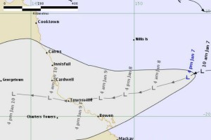
A tracking map of a tropical low approaching the Queensland coast
PHOTO: The tropical low is expected to bring heavy downpours over the next few days. (Supplied: BOM)
The heaviest rain fell at Halifax, east of Ingham, which recorded 681 millimetres in 24 hours and broke the 53-year-old national December record.
Further north, the Daintree experienced flooding and landslides, with almost a metre and a half of rainfall recorded during the December period.
"Rivers along the north tropical coast have had quite significant flooding in the last few weeks and the catchments are still saturated," Mr Banks said.
"So heavy rainfall, which could exceed 200 millimetres over relatively short periods, could see those rivers rise very rapidly."
Preparations underway, holidaymakers warned
A spokeswoman for the Cairns Shire Council said weather of this nature was seasonal and had been factored into earlier planning and preparations.
Far northern State Emergency Service (SES) regional director Wayne Coutts said crews were prepared for any impending deluge but urged the public to start their own planning.
Ex Tropical Cyclone Owen crosses the far north Queensland coast flooding a local park in Cairns.
PHOTO: Heavy rain from ex-Tropical Cyclone Owen caused flash flooding around Cairns on December 10, 2018. (ABC News: Anna Hartley)
He said the SES had responded to about 100 storm damage jobs in the Cairns region during recent weather events.
"Most of those were caused by poor maintenance on properties, not so much by damage from winds and trees — so if people could do [storm preparations] that would help the State Emergency Service out quite a lot," he said.
Although recent sunshine and hot weather had caused flooded areas to dry up and river and creek levels to subside, the SES warned flash flooding was always a risk.
"Unfortunately we've had two deaths recently due to flooded waters so it's really important for people to consider their options and have plans in place before anything bad happens," Mr Coutts said.
In Mackay, Deputy Mayor Amanda Camm said while the weather was "nothing out of the ordinary" for locals, there was concern for holidaymakers on flooded roads.
"In the [Eungella] National Park area, in the Finch Hatton Gorge area, when we've got visitors to the region or we've got people out in those areas where they're unfamiliar with those roads, certainly after heavy rainfall those roads are prone to flash flooding," Cr Camm said.
"If they don't know the road and they see water over the road ... turn around and go back."